富田林寺内町の探訪
I'm glad to intorduce an old town, Jinaimachi, Tondabayashi, Osaka, Japan as a national historic district and heritage site.
It takes 30 minutes from Osaka city to Tondabayashi station by Kintetsu railways. A 10-minutes walk will take you to the historic town.
ギャラリー
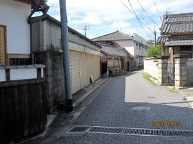
town planning - street arrangements, security and fire prevention
| 【Tourist guide to Jinaimachi town, Tondabayashi, a historic district and heritage site of Japan, town planning - street arrangements, security and fire prevention】 | |
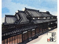
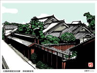
| Town Planning - street arrangements During the period of 1555 to 1558, Shoshuu Shonin, a Buddhist saint and the 16th head of Koushouji Temple in Kyoto looked for a location of mission and found a vacant field at the river terrace to the west of the banks of the Ishikawa River called Tonda-ga-shiba. Shoshuu Shonin asked the warlord, Naomasa Yasumi at the Takaya castle at the time of 1558 to trasnfer the proposed site and he purchased the property at the price equivalent to a thousand of bronze coins. Shoshuu Shonin called each two influential headmen from four neighboring villages of Nakano, Shindo, Ebitani and Yamachuda (collectively named as the eight headmen team of exploitation of Tondabashi ) , asked those believers to reclaim the wasteland, divided it into blocks, surrounded the outer edge by earthwork and bamboo forest and built up the temple in the center. This is Tondabayashi Gobo or Koushouji Betsuin Buddhist Temple and the foundation of Tondabayashi Jinaimachi town in 1560. The town was developed in all directions around Koushouji Betsuin Buddhist Temple or Tondabayashi Gobo, laying out the grid-shaped town plan with seven streets called suji and eight avenues called cho. Suji runs north to south and Cho runs east to west. The seven streets of suji are, in order from east to west, Higashi-suji, Kamegasaka-suji, Jyounomon-suji, Tomi-suji, Ichiba-suji and Nishi-suji. The remaining suji was a little narrower in width than the others and its trace and name was disappeared. The eight avenues of cho, in order from north to south, are Ichiriyama-cho, Tomiyama-cho, Kita Kaisho-cho (north Kaisho-cho), Minami Kaisho-cho (south Kiasho-cho), Sakai-cho, Gobo-cho, Nishi Hayashi-cho (West Hayashi-cho) and Higashi Hayashi-cho (east Hayashi-cho). Hayashi-cho was divided into the east one and the west one during the period of 1753-1778 and then the town has eventually consisted of six streets of suji and eight avenues of cho. |
|
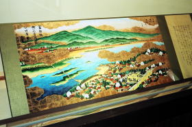 scroll of Kawachi regional attractions(1801) |
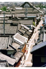
 aerial photograph of the whole town Photo: provided by Tondabayashi Municipality, unauthorized copying and replication are strictly prohibited. |
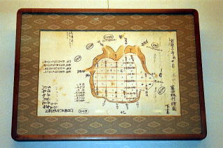 old illustrated village map in 1753 |
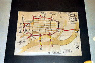 old illustrated village map in 1778 |
| Security - earthwork called Doi Jinaimachi town of Tondabayashi was originally developed as a religious mission town with autonomy during the age of provincial wars in Japan, approximately 1467-1590. It was in order to protect the peaceful commercial ward that the outer edge of the town was surrounded by earthwork called Doi (or Dorui) and bamboo forest was planted outside the edge and four wooden entrance gates were established and were opened in the morning and closed in the evening. The four gates were placed at the entrances of Yamachuda –zaka for Chihaya highway district, Kouda-zaka for Higashi Kouya highway district (south bound), West entrance for Hirao district and Ichiriyama for Higashi Kouya highway district (north bound) . Doi has been cut off flat, buried and incorporated into the townscape and its original position can no longer be confirmed now. The steep downslopes on the east and south side of the town and the difference in elevation at the west side of Jyoukokuji Buddhist Temple have shown the original topography from old times. In addition, it is said that a notice board was placed at the wooden gateway of Ichiriyama. Though the wooden gate had been solely left among the four gates after the Meiji era, it is said the gate was finally removed and relocated in the Taisho era. Nothing remains of the gate now. |
|
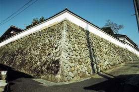 stone wall as remains of earthwork called doi or dorui is located at former residence of Nakamura Chouemon, a village headman at the end of Tokugawa Shogunate period, which was later used for regional administration office in Meiji era. |
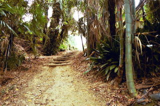 Sanga saka slope with bamboo forest, one of the entrances located in the south end of Jinaimachi town |
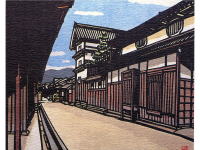
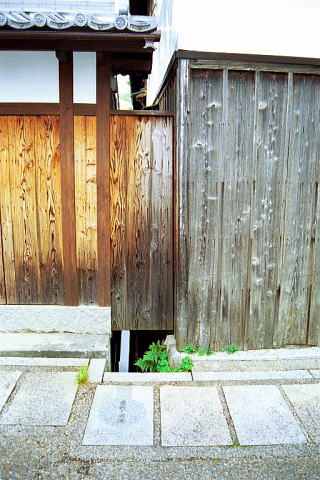
| Atemage-no-Michi (literally means “the road struck and bent”) The streets in the town area are laid out in a grid running north-south and east-west, and the original town planning has been left at present. For the security reason, the two streets crossing at right angles were slightly deviated on purpose, then the structure made it difficult for foreign enemy who invaded the town to foresee straight a distant place. The structure was often seen in castle towns at that time. |
|
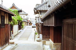 Jyounomonsuji street |
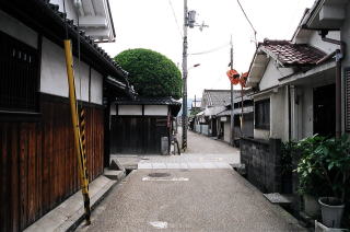 Kita kaisho-cho street |
| Fire-prevention The town is located at the hilltop of river terrace of Ishikawa River. Therefore, water supply was insufficient, and the residents of the whole town had extremely paid attentions on the prevention of the fire. There are ditches keeping firefighting water called the Youjin-Bori in Ichiriyama-cho and Tomiyama-cho in the north as well as the stone signpost at the entrance of town, describing the cautions that visitors are not supposed to walk around in smoking and to carry a cord being ignited in the town. Those facilities are understood for the residents to have protected the town for a long time, considering mutual benefit and prosperity of the community. Such considerations might be one of the reasons why the old townscape was left and preserved as it used to be. |
|
|
The preparation for fire prevention In addition, because of a hill of the river terrace, the water was inconvenient,
and the whole town paid extreme caution for the prevention of the fire. (the source: Tondabayashi Municipality Board of Education) |
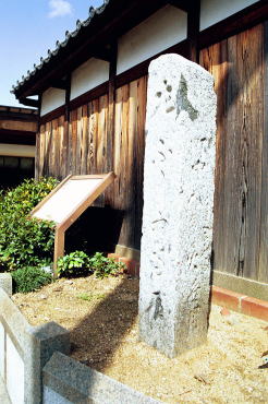 “No holding a burning match cord and and no holding a burning cigarette in the town” |
 The stone signpost is placed along the Higashi-Kouya highway at the south end of the town. |
|
| Youjin-Bori (Ditch for firefighting water) Youjin-Bori literally means a ditch of precautions against fire. A moat of precaution (a culvert) is placed along the Jyounomonsuji street, and the stone bridge across the moat is named as Gan-ei bridge, praying for the prosperity of Iwase-ya forever. |
|
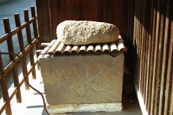 stone water pool for fire-fighting (residence of the Okutani family) |
 Yojin-bori, or a moat of precaution for fire-fighting and Ganei Bridge (residence of the Okutani family) |
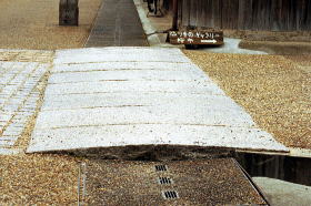
| Sewari-suiro |
|
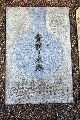 Sewari suiro is written on the surface of the stone tile along Jyounomonsuji street |
 Sewari suiro was placed at the boundary of the sites located nextdoor. |
 The north outer edge of Jinaimachi town the road is curved along the trace of moat. |
 The north outer edge of Jinaimachi town at the entrance of Nenzai-kuchi the road is curved along the trace of moat. |
Information

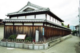
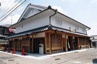
Jinaimachi in Tondabayashi(Jyounomon-suji street)
Photo: provided by Tondabayashi Municipality, unauthorized copying and
replication are strictly prohibited.
National conservation district of valuable traditional buildings
Jinaimachi town, a part of Tondabayashi-cho located in Tonadabayashi city
has been chosen as a national conservation district of valuable traditional
buildings since 1997, which is only selected in Osaka Prefecture. Among
approximately 500 buildings in the town, 181 buildings built during the
period from the Edo era to the early Showa era have been identified as
traditional buildings.
An application for prior approval to the section of cultural properties
in board of education of Tondabayashi city is required when any change
of current exterior appearances viewed from a street in the conservation
district such as enlargement, renovation, repair, redecoration, change
of the color, new construction and demolition of any buildings is to be
made. After repairing works for the conservation of the exterior appearances,
the reconstruction and face-lifting in consideration of landscaping, a
white wall, a board fence, and a lattice door of traditional house remain
as used to be, and rustic and calm atmosphere has been kept as people still
live in those houses.
The signpost is provided with main traditional residences to explain each
origin and history, and those guiding signposts cum street lights have
been placed along the streets of stone-pavement.
In addition, the appearances of newly built buildings are also harmonized
with the neighboring historic district in consideration for the traditional
townscape in Jinaimachi town.
Location
Jinaimachi town, Tondabayashi city, a national historic preservation district
and heritage site of Japan, which is located in the south-eastern part
of Osaka prefecture, the western part of Japan.
It is a 10-minute walk from the Tondabayashi Staion or the Tondabayashi
Nishiguchi Station of Kintetsu Nagano line.
From Kansai International Airport
Airport Limousine Bus service available bound for Kawachi Nagano Station.
(60 minutes) Please take Kintetsu railways from Kawachi Nagano to Tondabayashi.(15
minutes)
From Osaka International Airport (Itami Airport)
Airport Limousine Bus service available bound for Abenobashi Station. (30
minutes) Please take Kintetsu railways from Abenobashi terminal to Tondabayashi.(30 munites)
From JR Shinkasen Shin-Osaka station or
Osaka (Umeda) station
Please take Subway Midousuji line from Shin-Osaka station or Osaka (Umeda)
station to Tennoji Station. (20~30 minutes) Please change trains at Tennoji
and take Kintetsu railways from Abenobashi terminal to Tondabayashi. (30
minutes)
The site-seeing map available in English
Please stop by to the Tourist Information Cetnter or Jinaimachi Visitor
Center.
Restrooms
Available at Jinaimachi Visitor Center (Jinaimachi Kouryuukan), Jinaimachi
Center and Jinaimachi Tenbou Hiroba (Viewing Terrace)
Visitor Center
(Jinaimachi Kouryuukan,
Town Community Center)
Address
9-29, Tondabayashi-cho, Tondabayashi city, Osaka, 584-0033, Japan
TEL.+81-(0)721-26-0110
FAX.+81-(0)721-26-0110
open 10a.m. until 5 p.m.
closed on Monday
Visitor Parking
Road width is very narrow in Jinaimachi town. If traveling by car, please
use Tondabayashi Municipal east parking newly opened in February 2014 (Toll
parking).
You can park the minibus for groups and passenger cars for general use.
Only one parking lot available for minibus, you must book it in advance
with Tondabayashi City Hall. A 15-minute walk to the Jinaimachi Visitor
Center and 5 minute walk up to the former Sugiyama family house, an important
national cultural property.
You will note that you will contact Tondabayashi Municipality Office for
a parking lot of large tourist bus for groups. Thank you in advance for
your kind cooperation.